|
| County Kerry is one of the most popular counties in
Ireland with foreign tourists, and it is hardly surprising. There is
something for everyone in the County- beautiful countryside, mountains, wonderful
beaches, ancient sites to see, galleries to visit and countless sports to
pursue.
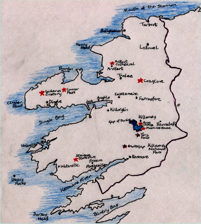
A lot of people base themselves in Killarney which is particularly good for exploring the Ring of Kerry and the Dingle Peninsula. Ardfert Castle
This series of churches was built honour Brendan the Navigator, who also
founded Clonfert Cathedral in Co.Galway. Brendan the Navigator was
born in 484 nearby and founded a monastery there. The Cathedral here
dates from the 12th century and has a Romanesque doorway. Inside there
is a statue of a 14th century Bishop. Banna Strand
Roger Casement an Irish Patriot, landed here in 1916 on a German U-Boat carrying
rifles for the Easter uprising. As soon as he landed he was arrested
and a memorial now stands on the site. Carrigafoyle Castle West of Ballylongford this 15th century castle belonged to the O'Connor Clan who ruled most of northern Kerry. It was constantly attacked by the English but it was Cromwell's forces who finally wrecked it in 1649. There is a Keep and ruined walled courtyard. You can climb the spiral staircase and get a view of the surrounding countryside. Dingle This very popular fishing village was once a remote Irish speaking town. The bay is very pretty with its fishing fleet based in the harbour. The town is full of craft shops and cafes. It is a good base for exploring the Dingle Peninsula with all its archaeological remains. Dingle these days is probably most famous for its famous resident, namely Fungie the Dolphin. He has lived in the area since 1983 and visitors can go out to see him on boating, snorkelling and diving trips. He is very intelligent and loves people. He is especially good with the disabled, children etc. The Dingle Peninsula The drive around the dingle Peninsula is 40km (25 miles)It is usual to drive from Dingle to Dunbeg Fort along the R559, also see the beehive huts, then onto Slea Head, Dunmore Head, see the view of the Blasket Islands. Onto the Blasket Centre, Ballyferriter, Riasc, the Gallarus Oratory and Kilmalkedar before returning to Dingle. Ballyferriter Baile an Fheirtéaraigh, is a pretty village with a museum which shows the cultural heritage of the area. There is also a wonderful pottery, and many pastel coloured cottages. A great place to stop and browse, have tea and buy a few gifts! Blasket Centre This centre explains the Blasket Island way of life, language and literature. The Islanders moved to the mainland in 1953 and this centre was built overlooking Blasket Sound. Dunbeg Fort An Dún Beag, was built during the Iron Age and is one of the best preserved in Ireland, and certainly worth a visit. Fahan Beehive huts Built by early christian pilgrims visiting the area ,these amazing beehive huts are situated close to Dunbeg Fort. Gallarus Oratory Gallarus was built between the 6th and the 9th centuries and resembles a boat turned upside down. It is the best preserved early church of this period in Ireland. The stones are laid at a slight angle, lower on the outside than the inside, making rain run off. It is built in the same way the neolithic tombs were built. There is one small window high up on the wall opposite the doorway. It is situated the dingle Peninsula on the R559 road. It overlooks Smerwick Harbour. Visitors can park their cars and walk across the field to view it. Kilmalkedar Kilmalkedar has a Romanesque church with stone carvings, sadly now ruined. It was once a place of pagan worship. the graveyard still has pagan stones, a cross and sundial. Riasc This 7th century monastic development was excavated. It has an oratory, several crosses and a pillar stone. Pillar stones were the precursors of the High Cross, and were inscribed with crosses and swirls. Slea Head As you drive round Slea Head the Blasket Islands come into clear view. The Crucifixion by the road is known locally as the Cross, An Cros. Kenmare It is situated on the mouth of the River Sheen. Kenmare was founded in 1670 by William Petty surveyor general to Cromwell. It was his descendent the first Marquess of Lansdowne who made it a model town of beautiful facades and decorative plasterwork in 1775. Kenmare is famous for its traditional lacemaking, a skill passed onto the local women during the famine by the nuns from the local convent of St. Clare's, who wanted to give them a skill they could sell. There are also hotels, restaurants and shops. It is also an ideal base from which to explore the ring of Kerry or the Beara Peninsula. Killarney Killarney is on most tourist's itineries, but this does not say that it is purely a "tourist town". There are many good shops, restaurants and hotels, and traditional jaunting cars (pony and traps) available to take you on sightseeing trips or a tour of the town. Nearby is Muckross House (see entry). The Lakes of Killarney Gap of Dunloe This dramatic mountain pass was carved by glaciers. There is a route through the gap with views of the mountains and lakes. A popular day out is to ride through the Gap of Dunloe from Kate Kearney's Cottage, either on horseback or by pony and trap, have lunch and then take a boat down the lakes. It is a lot of fun, but is best on a nice day. Tickets can be bought from the tourist office, hotels a Kate Kearney's Cottage. Kate Kearney's Cottage In the mid-19th century Kate Kearney ran a shebeen, (an illegal drinking-house) here. She sold poteen to the travellers passing by through the Gap of dunloe. she was also reportedly free with her charms. She was hounded by the law but the final blow happened with the blight attacked the potato crop, the basis of her poteen business. One night she vanished leaving the still behind. Today it is a pub with live music and dancing sometimes, a cafe, restaurant, and souvenir shop. It is also the starting point for the pony and trap, or horseback rides through the Gap of dunloe. Visitors cross a rugged 6 mile mountain pass between Macgillycuddy's Reeks and Purple Mountain, then go by boat down a river, across a lake to Ross Castle and back again. Ladies View This splendid view gets its name from a visit by Queen Victorias ladies-in-waiting in 1861. Lough Leane This is the largest lake in the area. Boat trips run between Ross Castle and Innisfallen, and there are many uninhabited islands. Meeting of the Waters This is where the waters from the Upper Lake meet Muckross Lake and Lough Leane. Ideally they should be viewed from Dinis Island. At he Old Weir Bridge the boats that take visitors down the lakes shoot the rapids. Muckross Abbey Muckross Abbey was founded in the 15th century by Donal MacCarthy Mor for the Franciscan monks. It is situated on the shore of the Lower Lake but is sadly now ruined. Torc Waterfall Signposts will direct you to a carpark where you can leave your car and make the short walk to see this beautiful waterfall. The Owengarriff River tumbles down into Muckross Lake through the wooded Friars' Glen. The path goes right to the top of the 18 meter, 60 foot drop, and takes you above the trees to see splendid views of Torc Mountain. Upper Lake Of the three lakes in the Killarney area, the Upper Lake, Muckross Lake and Lough Leane, the Upper Lake is the narrowest and smallest. It flows into the Long Range river and them meets the other two lakes at the meeting of the Waters. Muckross House This victorian house was built in 1843 overlooking Muckross lake. It is only a short distance from Killarney town (4km, 2.5 miles) and well worth a visit. The interior is beautifully furnished with fine furniture, many paintings, old musical instruments and a few dressed dummies to depict life back then. The house also houses a museum of Kerry life, with things such as butterchurns, which show the history of this part of Ireland. There is a craft centre too with many workshops. A short walk away is Muckross farm, a working farm which uses traditional techniques. The Ring of Kerry This route around the Iveragh Peninsula has been long established and can be driven around in either direction. It is about 180 km, 112 miles long. Allow a day to see all the beautiful mountain and coastal scenery. Starting point for either direction is Killarney town. I will describe the clockwise direction. From Killarney take the N71 south to Moll's Gap which cuts through high mountains and bogland. There are some stunning views here, and also a branch of the popular Avoca Handweavers shops which have a cafe, and sell quality irish products such as sweaters, glass, pottery, jewellery, rugs and so on. Follow the road south to Kenmare (see the separate entry) then take the N70 to Sneem. Sneem is a charming village with village green and brightly coloured cottages. Next visit Staigue Fort which is set up on a hill along a small road. This is the best preserved Iron-age stone fort, built without mortar. Its 13ft thick tightly fitting dry stone walls are very well preserved. The coastal scenery becomes even more spectacular round the coast. The next thing to note is Derrynane House the former home of Daniel O'Connell. It dates from the 17th century and now contains a museum about him. It is part of a 320 acre National Park that includes the house and mature woodland.Doire Fhionain as it is spelt in Irish means "St. Fionan's wood" after a 6th century monastery founded there by St. Fionan. There is no traceof the monastery there now. Derrynane harbour became a centre of thriving trade with France and Spain, there are stories of customs men trying to stop the export business run by the O'Connells and others from there and other little harbours around here. Young people also left from here to go abroad to get an education, something denied to Catholics in Ireland. Just outside Derrynane are several wedge-shaped tombs dating from the Beaker people who arrived here 4000 years ago.There is also a dolman dating from about 500 years ago set beyond the pub. From here the N70 turns north and goes through the Coomakista Pass then Waterville. At Caherciveen there is a local heritage centre. It is the main town on the Peninsula. At Glenbeigh you can stop to see the Bog Village, a collection of cottages which have all been reconstructed and date from the 1800s. Killorgan is a pretty village famous for its Puck Fair.Held every August a wild goat is crowned "king" at this traditional festival. The R562 then takes you back to Killarney town. The Skelligs The Skellig Experience on Valentia Island runs boat trips out to the Skelligs, which circle the islands but don't dock. there are no proper landing stages on the islands, except for an old pier on Skellig Michael. Tourists are discouraged from disturbing the wildbirds that nest and breed there. In the summer local fishermen also run trips from Portmagee or Ballinskelligs which sometimes stop at Skellig Michael for Visitors to climb to the top if they wish. It is doubtful if this practice can be allowed to continue indefinitely as it disturbs the archaeological remains. However it must be said it is amazing to be able to climb the ancient steps and see the ruins and the views are also fantastic. Little Skellig Little Skellig is slightly closer to the mainland than Skellig Michael. It covers some 17 acres and has sheer cliffs. It is home to thousands of seabirds and has one of the largest colonies of gannets in the British Isles, some 22,00 breeding pairs. Skellig Michael or Great Skellig Great Skellig, or Skellig Michael is a fairly inhospitable island of rock which covers 44 acres and rises some 218 m (714 ft) above sea level.On the top is an ancient Christian Monastery reached by a 1,000 year old stairway cut out of the rock. The Monks settled on Skellig Michael in the 6th century when they built 6 beehive cells and two boat shaped oratories. These structures built without mortar ,are still standing centuries later despite being battered by numerous storms. Surprisingly, looking at the bare rock of the island, the monks were self sufficient. They traded seal meat, eggs and feathers with passing boats for tools, cereals and animal skins. The skins were used as vellum on which the monks copied their religious manuscripts. The monks remained on the island until the 12th century when they moved to the mainland at the Angustinian priory at Ballinskelligs. Now thousands of seabirds are the only residents - storm petrols, puffins, and manx shearwaters. Here they can breed in peace free from the fear of any predator. Staigue Fort Situated on the route of the Ring of Kerry on the Iveragh Peninsula, this is the best preserved Iron-age, dry-stone fort in Ireland. The circular wall still stands and is amazing to see. It can be reached by driving up a small road to where it is perched on the hillside. Tralee The town is probably most famous for its Rose of Tralee competition which is held here every year at the end of August. However there is more to the town than that. Blennerville Windmill This is Ireland's largest working mill which was built in 1800. It is just outside of Tralee and is a very popular attraction. Kerry County Museum This excellent museum has various displays and interactive models. there is an audio-visual show on Kerry scenery, and a "time travel" experience, where you travel through Anglo-Norman Tralee complete with smells! They have many archaeological finds on display. Siamsa Tire This is the base of a folklore theatre who put on many shows of traditional song and dance in the summer. Steam Railway This narrow gauge railway connects Blennerville to Tralee. It leaves from Ballyard and goes to the Windmill (see above entry). There are trips on the train with running commentaries. Valentia Island Valentia is an island joined to the mainland by a causeway to Portmagee. It is 11km (7 miles) long. It has terrific views from Geokaun Mountain, especially of the sea and it is also popular for water sports. It is also close to the Skellig Islands which lie about 15km, 10 miles south west of the Iveragh Peninsula. Knightstown This is the main village on Valentia which has pubs with music and dancing and places to stay. The first cable across the Atlantic was laid from the Island to Newfoundland in Canada in 1866. The Skellig Experience centre Situated near the causeway that links Valentia to the mainland this centre houses a display about the building of the monastery on Skellig Michael, the largest of the islands. They also have displays on the birds and wildlife of the islands. The Skellig cliffs lie underwater for a depth of 50 meters, 165 feet, and provide a great habitat for giant basking sharks, dolphins and turtles. The centre also operates cruises round the islands. Waterville Waterville has been popular with many famous people for their holidays. charlie Chaplin spent many holidays with his family here in the 1960's and 70's. In The Butler Arms, the hotel where they stayed there is a "Chaplin Lounge" with photos of the family on the walls. Walt Disney and George Bernard Shaw also stayed here. There is a lovely beach and nearby several good fishing lakes.
|